
Result description
Knowledge Graph for biodiversity is a tool to integrate and harmonise siloed ecological data, allowing more effective and efficient scientific research and discovery, data sharing and collaboration. The Knowledge Graph is integrated in the citizen science data collector app (Cluey), habitat mapping, and the bear HWC radar.
The Knowledge Graph allow for more accurate and reliable AI models, the ability to infer ecological interactions, faster discovery of new ecological patterns and with greater accuracy, improved Environmental, Social and Governance (ESG) reporting.
The Knowledge Graph (KG) is designed to support a broad spectrum of users working at the interface of biodiversity, environmental data, and digital technologies:
- Research institutions and scientists benefit from a semantically integrated platform that enables complex ecological queries, supports species distribution modelling, and accelerates discovery through linked datasets.
- Policymakers and environmental authorities can access harmonised biodiversity data aligned with EU directives (e.g. Habitats Directive, Nature Restoration Law), enabling informed decision-making and robust environmental reporting.
- Technology developers and AI/ML practitioners gain access to structured, machine-readable biodiversity data, improving model training and predictive performance for conservation-focused applications.
- ESG analysts and sustainability consultants can track environmental indicators and conservation impact, feeding data into corporate and public sustainability assessments
- Conservation organisations and NGOs benefit from better coordination, data interoperability, and evidence-based programme planning through a shared knowledge infrastructure.
Addressing target audiences and expressing needs
- We are sharing our knowledge
- Others/ No specific audience
- Research and Technology Organisations
- Academia/ Universities
R&D, Technology and Innovation aspects
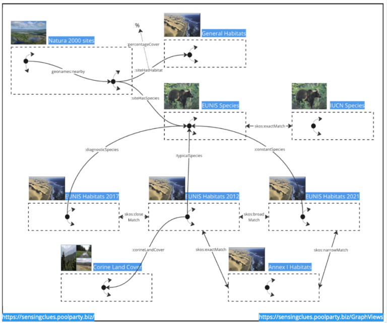
Nature FIRST Knowledge Graph integrates diverse datasets related to biodiversity and conservation. These include information on Natura 2000 sites, habitat data from multiple versions (2012, 2017, 2021), species data from EUNIS and the IUCN Red List, CORINE Land Cover classifications, and more.
Next step is to integrate relevant biodiversity sources that consist of unstructured data
Result submitted to Horizon Results Platform by 3EDATA INGENIERIA AMBIENTAL SL