

Result description
Real-time information about bear presence to avoid conflicts, increase awareness, and promote coexistence.
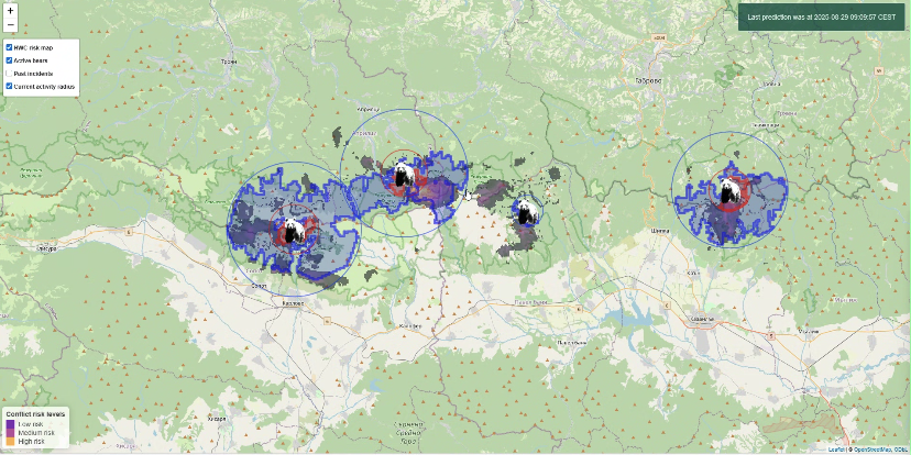
This tool provides timely information about bear-presence and threats for humans and their assets (e.g. apiaries). The radar is underpinned by a species digital twin model (which can be adapted to other animals / large carnivores).
Potential users are: public authorities, conservationists/NGOs, rangers, bear emergency team members, and park managers in areas with large carnivores.
Impact: By being alerted, human-wildlife conflicts can be avoided, fewer people, assets and animals wounded or killed. The result is greater awareness, less fear and higher acceptance by the local community.
The Human-Bear Conflict (HBC) Radar targets a wide range of stakeholders dealing with human-bear interactions in regions where Ursus arctos (brown bear) is present:
- Local communities (residents, farmers, beekeepers): Gain timely notifications about nearby bear activity, enabling effective planning to reduce property damage.
- Protected area managers & rangers: Access real-time data and predictions to prioritise interventions, minimise conflict, and coordinate with the public.
- Municipalities and law enforcement: Use risk maps and incident reporting to plan bear-safe infrastructure, guide patrolling, and respond quickly to urgent situations.
- Tourism operators (hoteliers, tour guides, local businesses): Provide safety advice and reduce negative encounters between visitors and wildlife.
- NGOs & wildlife conservation organisations: Evaluate the effectiveness of coexistence strategies, track conflict trends, and advocate solutions to authorities.
Addressing target audiences and expressing needs
- We are sharing our knowledge
- Collaboration
We are looking for people who would like to help or fund further development of the Human Bear Conflict Radar
- Others/ No specific audience
- Research and Technology Organisations
- Academia/ Universities
R&D, Technology and Innovation aspects
To stimulate the uptake of DTs (which we refer to, outside the academic arena, as Radars), we conceptualised three levels of sophistication:
- Radius Radar
- Advanced Risk Radar
- Research Radar
By defining and offering these 3 options, we try to ensure that the radars are within (financial) reach of all organisations that are engaged in HWC mitigation.
Result submitted to Horizon Results Platform by ASOCIATIA WWF ROMANIA