
Result description
The EU Water Framework Directive (WFD) applies in principle to all surface waters in the EU. The purpose is to achieve a good ecological and chemical status. For those waters for which the ecological and/or chemical status is not good, measures should be implemented to improve this status for the next WFD reporting period. Several parameters that are used to determine the ecological status can be measured by Earth Observation
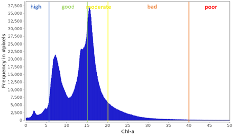
The purpose of the WFD is to achieve a good ecological and chemical status in all waters in EU. Such status is derived from measurements of a large range of parameters related to the water quality and ecological status. Which parameters are measured depends on the water environment. For each water body, a ‘reference status’ has been described, and the current status for each parameter is calculated relative to this reference. Many EU countries use their own reference water types, their own monitoring methods and their own methods for the calculation of the ecological status. To determine WFD status by sampling is not cost-effective and leads to knowledge gaps.
The launch of the Sentinel satellites has opened up new opportunities for consistent monitoring of coastal ecosystem quality. Satellite methods are faster, more cost-effective and produce map outputs providing a more synoptic view of the study area with a good spatial detail and temporal coverage. EO data can be used to measure or provide proxies for WFD parameters such as: Composition of phytoplankton, Abundance of phytoplankton, Transparency and Thermal conditions
Addressing target audiences and expressing needs
- To raise awareness and possibly influence policy
- Grants and Subsidies
- Loans
A good water quality is the base of a healthy ecosystem with rich biodiversity. Aquatic ecosystems also provide essential services for drinking water, irrigation, recreation, aquaculture and fisheries. The EU Water Framework Directive recognizes this and requires member states to monitor and, if necessary, improve water quality. Although the spatial component is key to gain insight in the processes in water, regular sample-based monitoring only provides point data.
We provide mapping services for water managers and we want to raise awarenesss for those involved in the regulations that EO data can be a valuable data source to support the WFD.
- Public or private funding institutions
- EU and Member State Policy-makers
- Other Actors who can help us fulfil our market potential
R&D, Technology and Innovation aspects
Methods and algorithms have been developped and validated for the basic products that are used to produce WFD indicator results.
Can be rolled out to other countries and areas, taking in account the local WFD thresholds
Well documented processing steps
Remote sensing is a clean way of monitoring large water surfaces
- Europe
- North America
Result submitted to Horizon Results Platform by WATER INSIGHT BV