Result description
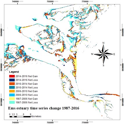
Coastal and especially estuarine environments are characterized by high sediment dynamics. The distribution of sediments over an area will change depending on discrete events (high river run-off, spring-tides) or gradual events (such as sea level rise) resulting in changes in coastline. Satellite remote sensing can be used to monitor those changes.
What is the problem
Estuarine coastal morphology is strongly influenced the sediments discharged by rivers and the dynamic distribution of water and sediments caused by processes such as tides, sea currents, storm surges, river discharge fluctuations etc. In the Dutch Wadden Sea the morphology changes from year to year and with it the connected ecosystems. Traditional monitoring cannot provide information on the required scales.
CoastObs solutions
The launch of the Sentinel satellites has opened up new opportunities for consistent monitoring of coastal ecosystem quality. Satellite methods are faster, more cost-effective and produce map outputs providing a more synoptic view of the study area with a good spatial detail and temporal coverage. This allows to adequately monitor the changes in coastline.
Addressing target audiences and expressing needs
- To raise awareness and possibly influence policy
- Grants and Subsidies
- Loans
Coastal and especially estuarine environments are characterized by high sediment dynamics. The distribution of sediments over an area will change depending on discrete events (high river run-off, spring-tides) or gradual events (such as sea level rise) resulting in changes in coastline. Erosion will occur in high flow conditions and accretion in the opposite situation. A typical example of a dynamical coastal system with continuous coastline changes is a bird foot delta. Monitoring changes is important for local risk assessment and shoreline management by local, national or international governmental organisations.
- Public or private funding institutions
- EU and Member State Policy-makers
- International Organisations (ex. OECD, FAO, UN, etc.)
R&D, Technology and Innovation aspects
Methods to monitor coastline changes at a resolution of 10 m or less have been established and can be operationally provided as service.
Roll out to other countries possiblee
Methods are well documented
Earth Observation data is a sustainable method for monitoring
- Global
Result submitted to Horizon Results Platform by WATER INSIGHT BV