

Result description
Wind energy planning is often slowed down by lack of accessible information, low public acceptance, and limited tools to support dialogue. The WIMBY platform addresses these barriers by providing open, harmonised data layers, transparent impact assessment, and participatory features that help stakeholders understand trade-offs, evaluate scenarios, and engage in constructive discussions.
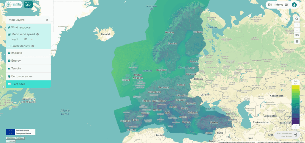
The WIMBY Web-GIS Interactive Platform is a user-friendly digital environment designed to support transparent, inclusive and informed decisions about wind energy deployment. It combines environmental, societal and technical datasets into an integrated map interface, enabling users to explore constraints, opportunities and cumulative impacts of wind development at local, regional and European scales. The platform also includes a discussion forum that facilitates structured dialogue among citizens, planners, policymakers and experts. It was co-designed and validated through multi-stakeholder workshops in pilot regions and is freely accessible online.
Addressing target audiences and expressing needs
- To raise awareness and possibly influence policy
- Use of research Infrastructure
- Collaboration
We are looking for partners, authorities, and organisations interested in adopting, testing, or further developing the WIMBY tools and frameworks. Specifically, we seek:
- Public authorities willing to integrate the Web-GIS and 3D tools into planning or consultation processes
- Researchers and universities interested in using the tools for teaching and further scientific development
- Policymakers and EU-level platforms supporting wider dissemination and replication
- Projects or initiatives aiming to build on WIMBY’s results at higher TRLs
- EU and Member State Policy-makers
- Research and Technology Organisations
- Academia/ Universities
R&D, Technology and Innovation aspects
The interactive platform is fully developed and operational. It is currently being utilised for conference and workshop demonstrations, and also in university lectures by consortium partners. As the project concludes, the following steps are highly desirable for long-term operability and impact:
- Optimisation and expanded dataset integration.
- Implementation in specific regional planning processes.
The platform can scale through:
- API-based revenue models,
- tiered access for industry (while remaining free for citizens),
- consultancy packages linked to data customisation,
- integration with third-party planning platforms.
The platform is replicable in any European region or municipality by adjusting local datasets and regulatory layers. The architecture is designed to import new geospatial data seamlessly.
Sustainability is ensured through:
- modular architecture allowing updates,
- open-source components,
- low operational costs,
- potential institutional adoption by universities, NGOs, and regional authorities,
- scalable paid API calls and premium services for industry.
- Europe
Result submitted to Horizon Results Platform by APREN-ASSOCIACAO PORTUGUESA DE ENERGIAS RENOVAVEIS